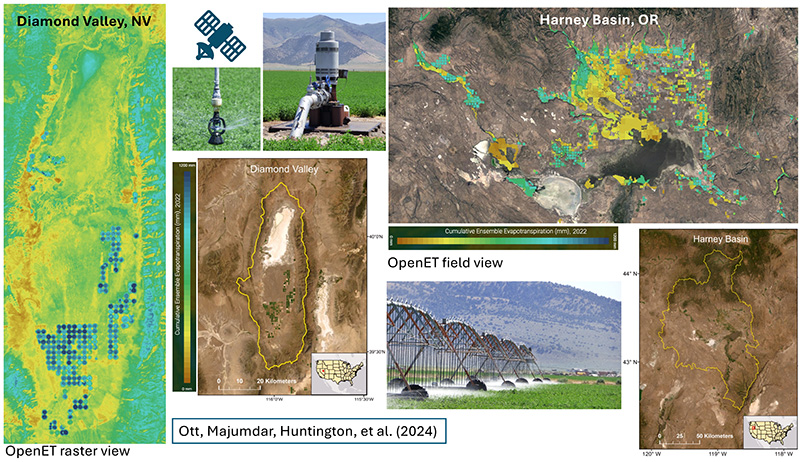
DRI scientists compare data from groundwater pumping meters with OpenET estimates in irrigated land to advance understanding of groundwater use.
Reno, Nev. (September 5, 2024) – Drought is a widespread concern in the Western U.S., and water managers across the region are developing groundwater management plans to conserve the essential resource. Groundwater is often pumped to the surface to irrigate crops, and meters that measure the flow of pumped water have historically offered the best information on groundwater use. These meters are rare, however, so DRI scientists set out to determine whether OpenET, a platform that measures evapotranspiration using satellite data, could help fill this information gap.
The new study, published August 8th in a special issue of Agricultural Water Management, compared groundwater meter data with OpenET estimates for agricultural fields in Nevada and Oregon. The results demonstrate that OpenET can be used to accurately estimate the amount of groundwater used for crop irrigation at the level of individual fields. This is the first research to follow water from a groundwater well to a single field of crops, assess how much of that water the crops consumed, and provide insights into irrigation efficiencies at the same time. The method can inform water use for groundwater management planning across the country.
“We knew where the water was drawn from and where it was being applied, and we showed that the satellite data could tell us how much crop water use and pumping occurred for individual fields,” said Thomas Ott, assistant research scientist of hydrology at DRI and a lead author of the study. Access to detailed meter data is rare, Ott adds, so past studies focused on broader regions and couldn’t assess water use at the level of individual fields.
Evapotranspiration refers to the combined processes of evaporation and transpiration, or the return of water to the atmosphere from Earth’s surface and through plant photosynthesis. OpenET uses data from NASA and U.S. Geological Survey Landsat satellites combined with weather variables like humidity, air temperature, and solar radiation to estimate evapotranspiration for landscapes around the world.
The study centered on two agricultural regions with irrigation water flow meters that could be compared to the OpenET data: Diamond Valley, Nevada and Harney Basin, Oregon. Both regions have thousands of acres of irrigated alfalfa and hay and rely heavily on groundwater. In Diamond Valley, there was a 7% difference between the metered data and the OpenET estimates for water use, while Harney Basin showed a lower accuracy rate at a 17% difference. The researchers wanted to examine how the OpenET results would perform across different irrigation systems, with Diamond Valley relying on center-pivot sprinklers and Harney Basin utilizing a mix of flood irrigation and sprinklers.
“Our study shows that OpenET can really advance our understanding of agricultural water use, especially in basins without monitoring in place,” Ott says. “Traditional methods often use an estimate of the maximum water use for a typical healthy field in a typical year, but lots of factors can bring that number down. Using satellite data gives a more realistic value.”
In fact, by comparing the metered data and OpenET estimates, the study found that assumed values for water use in Diamond Valley were far higher than the amount of water actually used, says Sayantan “Monty” Majumdar, assistant research professor of hydrologic sciences and remote sensing at DRI and a lead author on the study. With information about the total amount of groundwater pumped to a field and the OpenET estimate of water used by the crop, the researchers also found that water use in the two study areas was highly efficient, with 90% of irrigation water used by the crop in Diamond Valley, compared to 83% in Harney Basin.
Ott, Majumdar, and the rest of the DRI OpenET team plan to expand this research to quantify the amount of water used in agriculture across Nevada as part of the Nevada Water Initiative. Nevada is the driest state in the nation and currently relies on estimates of water availability and use that are decades old, and the initiative will utilize advances in research methods and technology to provide a more robust assessment for informing water management moving forward. The project is a collaboration between DRI, the Nevada Division of Water Resources, and the USGS Nevada Water Science Center, as well as agricultural stakeholders across the state.
“The stakeholder engagement for this work is so important,” Ott says. “Having grown up on a dairy farm myself, it was amazing to go into different parts of Nevada and see how the farmers work. One farmer graciously hosted me for a month while I was doing field surveys of meters and irrigation systems, and building those relationships is really important for our future work.”
– @driscience –
More information: The publication, Toward field-scale groundwater pumping and improved groundwater management using remote sensing and climate data, can be found in Agricultural Water Management at: https://doi.org/10.1016/j.agwat.2024.109000
For more information on OpenET, visit: https://etdata.org/
Authors include: Thomas Ott (DRI), Sayantan Majumdar (DRI), Justin Huntington (DRI), Christopher Pearson (DRI), Matt Bromley (DRI), Blake Minor (DRI), Peter ReVelle (DRI), Charles Morton (DRI), Sachiko Sueki (DRI), Jordan Beamer (Oregon Water Resources Department), and Richard Jasoni (DRI)
About DRI
We are Nevada’s non-profit research institute, founded in 1959 to empower experts to focus on science that matters. We work with communities across the state — and the world — to address their most pressing scientific questions. We’re proud that our scientists continuously produce solutions that better human and environmental health.
Scientists at DRI are encouraged to follow their research interests across the traditional boundaries of scientific fields, collaborating across DRI and with scientists worldwide. All faculty support their own research through grants, bringing in nearly $5 to the Nevada economy for every $1 of state funds received. With more than 600 scientists, engineers, students, and staff across our Reno and Las Vegas campuses, we conducted more than $47 million in sponsored research focused on improving peoples’ lives in 2023 alone.
At DRI, science isn’t merely academic — it’s the key to future-proofing our communities and building a better world. For more information, please visit www.dri.edu.
Media Contact
Elyse DeFranco
Science Writer, DRI
Elyse.defranco@dri.edu