Since 2018, the Innovation Research Program (IRP) has provided critical seed-funding for early-stage research at DRI. To date, this program has supported more than 20 research teams and several successful research programs have grown out of IRP-supported preliminary research. However, public funds to support “start-up” environmental research of this type are extremely limited.
This giving season, please join us in supporting bright minds and their best ideas by donating to the IRP Endowment, which was established earlier this year to ensure that innovative science continues for generations to come. Your gift will bring us one step closer to our goal of raising $5 million to fully fund this endowment.
IRP Endowment funds go directly to the scientists themselves as they carry on DRI’s legacy of advancing science that matters now. With a gift to the IRP Endowment, you will be part of this legacy by ensuring that groundbreaking environmental research will continue for generations to come.
And… thanks to generous matches from the Tom and Mary Gallagher Foundation and the Bretzlaff Foundation, your gift to the IRP Endowment will have DOUBLE the impact.
Please consider helping fund critical research that fuels a better future.
The Nell J. Redfield Foundation recently made a three-year commitment to support Nevada Robotics’ Books and Bots Teacher Trainings, which will provide classroom lessons in Pre-Kindergarten through fifth grade classrooms using robots and storybooks.
Thanks to the Redfield Foundation’s generous support, Nevada Robotics will host ten trainings over the next three years for eight Redfield Community Outreach Program (RCOP) elementary schools in Northern Nevada, with the goal of reaching students, educators, and families that have not previously received this training. Educator stipends and ongoing classroom support will be provided, as well as the necessary robots, books, and other training materials.
These trainings will have significant long term positive benefits for Northern Nevada educators and students. Through the estimated 40 educators reached at the end of the third year, roughly 1,280 students will benefit from these lessons year after year. Further, recent studies have identified a positive link between early STEM education and language & literacy skills. Overall, Nevada Robotics seeks to increase equity and access to computer science and STEM skills for Nevada students, thereby better preparing them for a technology-driven world.
Thank you to the Nell J. Redfield Foundation for helping DRI’s Nevada Robotics to create a better future for the people of Nevada and the world.
If you are interested in supporting DRI’s Nevada Robotics, click here.
This generous gift was made to DRI and Nevada Robotics in memory of Gerald “Jerry” Smith and his dedicated work to the Nell J. Redfield Foundation’s mission.
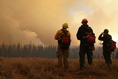
Reno, Nev. (September 10, 2024) – Guo Yu, assistant research professor of hydrometeorology, along with collaborator Luke McGuire from the University of Arizona, received a three-year grant from the USGS Water Resources Research Act Program. The funding will be used to expand his work examining how repeated wildfires impact flooding risk in communities. In a study based on this research published in December 2023, Yu found that peak floods can be up to three times larger in the first year following a large wildfire. When a severe wildfire burns through a landscape, soil-stabilizing plant roots are lost, while the soil itself can turn water-repellent, enhancing flood risk. The research uses the concept of flood frequency analysis as a tool to estimate the relationship between the severity of flooding and the probability that it will occur.
The new funding will allow Yu and a future doctoral student to improve on the framework by accounting for the impacts of climate change, such as lengthened vegetation recovery time in drought years, on flooding risk.
“This research is critical for understanding how increased wildfire risk under a changing climate will impact flooding risk to western communities,” Yu says.
The $300,000 USGS grant was matched by DRI and the University of Arizona, providing $600,000 total over three years for the research. Yu anticipates hiring a Ph.D. student through the Graduate Program of Hydrologic Sciences to begin work on the project in 2025. Prospective students who are interested in this project can contact Guo Yu directly.
In addition to the research, the award will be used to support the DRI STEM Education Program’s educator professional development trainings on fire ecology. The trainings invite Nevada K-12 teachers to DRI campuses in Reno and Las Vegas to offer scientific training on focused topics for educators to transmit to their students. Many of the trainings are paired with educational kits known as Green Boxes, which are prepared by the STEM Education Team in partnership with DRI scientists and offered free to schools statewide.
“Sixty years ago, DRI helped initiate what has become the USGS Water Resources Research Act Program, and currently hosts the Nevada Water Resources Research Institute. We’re proud to contribute to the program’s goal of using robust scientific research to resolve the West’s water problems while training future scientists,” says Sean Mckenna, executive director of hydrologic sciences at DRI.
We are Nevada’s non-profit research institute, founded in 1959 to empower experts to focus on science that matters. We work with communities across the state — and the world — to address their most pressing scientific questions. We’re proud that our scientists continuously produce solutions that better human and environmental health.
Scientists at DRI are encouraged to follow their research interests across the traditional boundaries of scientific fields, collaborating across DRI and with scientists worldwide. All faculty support their own research through grants, bringing in nearly $5 to the Nevada economy for every $1 of state funds received. With more than 600 scientists, engineers, students, and staff across our Reno and Las Vegas campuses, we conducted more than $47 million in sponsored research focused on improving peoples’ lives in 2023 alone.
At DRI, science isn’t merely academic — it’s the key to future-proofing our communities and building a better world. For more information, please visit www.dri.edu.
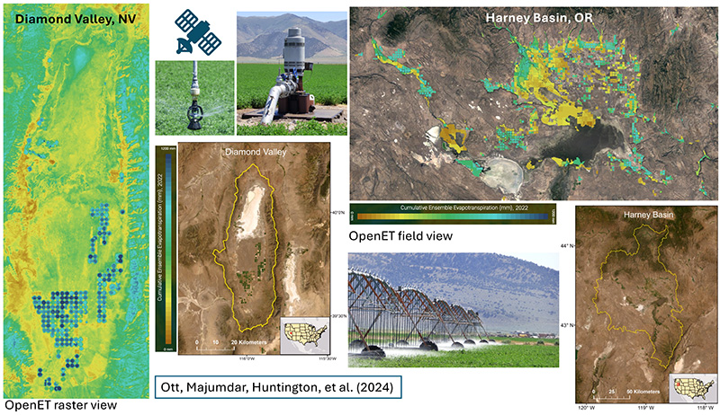
DRI scientists compare data from groundwater pumping meters with OpenET estimates in irrigated land to advance understanding of groundwater use.
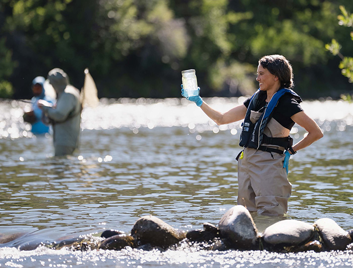
Reno, Nev. (September 5, 2024) – Drought is a widespread concern in the Western U.S., and water managers across the region are developing groundwater management plans to conserve the essential resource. Groundwater is often pumped to the surface to irrigate crops, and meters that measure the flow of pumped water have historically offered the best information on groundwater use. These meters are rare, however, so DRI scientists set out to determine whether OpenET, a platform that measures evapotranspiration using satellite data, could help fill this information gap.
The new study, published August 8th in a special issue of Agricultural Water Management, compared groundwater meter data with OpenET estimates for agricultural fields in Nevada and Oregon. The results demonstrate that OpenET can be used to accurately estimate the amount of groundwater used for crop irrigation at the level of individual fields. This is the first research to follow water from a groundwater well to a single field of crops, assess how much of that water the crops consumed, and provide insights into irrigation efficiencies at the same time. The method can inform water use for groundwater management planning across the country.
“We knew where the water was drawn from and where it was being applied, and we showed that the satellite data could tell us how much crop water use and pumping occurred for individual fields,” said Thomas Ott, assistant research scientist of hydrology at DRI and a lead author of the study. Access to detailed meter data is rare, Ott adds, so past studies focused on broader regions and couldn’t assess water use at the level of individual fields.
Evapotranspiration refers to the combined processes of evaporation and transpiration, or the return of water to the atmosphere from Earth’s surface and through plant photosynthesis. OpenET uses data from NASA and U.S. Geological Survey Landsat satellites combined with weather variables like humidity, air temperature, and solar radiation to estimate evapotranspiration for landscapes around the world.
The study centered on two agricultural regions with irrigation water flow meters that could be compared to the OpenET data: Diamond Valley, Nevada and Harney Basin, Oregon. Both regions have thousands of acres of irrigated alfalfa and hay and rely heavily on groundwater. In Diamond Valley, there was a 7% difference between the metered data and the OpenET estimates for water use, while Harney Basin showed a lower accuracy rate at a 17% difference. The researchers wanted to examine how the OpenET results would perform across different irrigation systems, with Diamond Valley relying on center-pivot sprinklers and Harney Basin utilizing a mix of flood irrigation and sprinklers.
Maps and photos of the study areas, Diamond Valley, Nevada (left), and Harney Basin, Oregon (right). The figure on the far-left shows Diamond Valley evapotranspiration (ET) image data (raster view) from the OpenET ensemble mean for 2022. Irrigated fields are shown in blue. The figure on the top right (field view) shows the ET data from the OpenET ensemble mean (2022) only for irrigated fields in Harney Basin. The researchers rely on satellite remote sensing-derived ET data from OpenET and compare with readings from high-quality magnetic flow meters fitted on the pumps (top center). The pumped groundwater is then applied to the fields using irrigation systems such as the one on the bottom showing an active center pivot system over an alfalfa field in Diamond Valley. A zoomed in view of a sprinkler nozzle spraying the pumped groundwater is shown on the top left.
“Our study shows that OpenET can really advance our understanding of agricultural water use, especially in basins without monitoring in place,” Ott says. “Traditional methods often use an estimate of the maximum water use for a typical healthy field in a typical year, but lots of factors can bring that number down. Using satellite data gives a more realistic value.”
In fact, by comparing the metered data and OpenET estimates, the study found that assumed values for water use in Diamond Valley were far higher than the amount of water actually used, says Sayantan “Monty” Majumdar, assistant research professor of hydrologic sciences and remote sensing at DRI and a lead author on the study. With information about the total amount of groundwater pumped to a field and the OpenET estimate of water used by the crop, the researchers also found that water use in the two study areas was highly efficient, with 90% of irrigation water used by the crop in Diamond Valley, compared to 83% in Harney Basin.
Ott, Majumdar, and the rest of the DRI OpenET team plan to expand this research to quantify the amount of water used in agriculture across Nevada as part of the Nevada Water Initiative. Nevada is the driest state in the nation and currently relies on estimates of water availability and use that are decades old, and the initiative will utilize advances in research methods and technology to provide a more robust assessment for informing water management moving forward. The project is a collaboration between DRI, the Nevada Division of Water Resources, and the USGS Nevada Water Science Center, as well as agricultural stakeholders across the state.
“The stakeholder engagement for this work is so important,” Ott says. “Having grown up on a dairy farm myself, it was amazing to go into different parts of Nevada and see how the farmers work. One farmer graciously hosted me for a month while I was doing field surveys of meters and irrigation systems, and building those relationships is really important for our future work.”
– @driscience –
More information: The publication, Toward field-scale groundwater pumping and improved groundwater management using remote sensing and climate data, can be found in Agricultural Water Management at: https://doi.org/10.1016/j.agwat.2024.109000
We are Nevada’s non-profit research institute, founded in 1959 to empower experts to focus on science that matters. We work with communities across the state — and the world — to address their most pressing scientific questions. We’re proud that our scientists continuously produce solutions that better human and environmental health.
Scientists at DRI are encouraged to follow their research interests across the traditional boundaries of scientific fields, collaborating across DRI and with scientists worldwide. All faculty support their own research through grants, bringing in nearly $5 to the Nevada economy for every $1 of state funds received. With more than 600 scientists, engineers, students, and staff across our Reno and Las Vegas campuses, we conducted more than $47 million in sponsored research focused on improving peoples’ lives in 2023 alone.
At DRI, science isn’t merely academic — it’s the key to future-proofing our communities and building a better world. For more information, please visit www.dri.edu.
The report offers information about incorporating publicly available climate data into emergency planning and exercises
Reno, Nev. (September 4, 2024) – Climate change is fueling more severe storms and floods, droughts and fires, and communities around the world are grappling with how to prepare. Emergency managers regularly meet to examine possible disasters and discuss preparations and responses for protecting the public, but often default to using past disasters as examples. This fails to capture the extent of potential damage from future weather extremes, so DRI scientists partnered with the U.S. Geological Survey to produce a guidance document for incorporating publicly available data on historical and projected extreme weather events to aid with emergency planning exercises. The report, funded by the California Department of Water Resources, is available on DRI’s website.
Although many public agencies will find the report helpful, it is written with two groups in mind. The first, emergency management practitioners, will find information about data available for exercises that reflect the most current state of climate science projections and the increased risk they carry. The second part of the report is directed toward data developers, the people who build the scenarios used in emergency response exercises. The report offers techniques for building these scenarios and guidance for presenting the information in a useful form for emergency managers.
“Emergency response planners, critical infrastructure owners and operators, and natural resource managers in our region face impacts from increasingly frequent and severe atmospheric river (AR) storm events due to global warming,” says Maureen McCarthy, research professor of environmental science at DRI and a lead author of the report. “Damage from these extreme storms cost millions of dollars in response and long-duration recovery funding and put Tribal and underserved communities at particularly high risk. This primer provides a guide for emergency planners to develop scenarios that can test their ability to anticipate, respond, and recover from these events and to inform actions for strengthening community resilience in the future.”
The report focuses on the use of climate data, including temperature, precipitation, and wind, to create computer simulations and maps that illustrate how the timing and locations of impacts may play out. These visualizations provide a foundation for discussing how emergency managers and others in the community might prepare or respond if the event were to happen in real life. This is particularly helpful for stretching planners’ understanding of how the impacts of a wildfire, flood, or drought may extend beyond the reach of past events.
Figure 2 from the report shows the links between natural hazards to consider in emergency planning.
“There’s been a lot of work into incorporating climate change into adaptation planning in California and Nevada, but this hasn’t been included in emergency management activities quite as much,” says Christine Albano, ecohydrologist at DRI and lead author of the report. “In many cases, emergency managers will use a historical storm for their exercise scenario and make it qualitatively more severe to address climate change, but we’re advocating for creating scenarios that are more quantitative so that maps, visuals, and data help people to conceptualize what might happen more vividly. We also propose methods for creating scenarios that represent our best knowledge of how storms or other hazards might be different from those we have seen before. The hope is that it spurs deeper conversations informed by data.”
The data and amount of work required for creating and visualizing different events will vary, Albano says, and the report also offers guidance on taking this into account. For example, a landslide or wildfire will require data that reflect the quickly evolving nature of the emergency, such as by the minute or hour, and over a relatively small area. However, planning for drought response would likely only require daily data but would affect a very large region. Understanding these differences helps emergency managers streamline their data needs and planning.
Figure 3 from the report shows guidance on the temporal resolution needed to simulate various extreme weather events.
Albano and her co-authors used lessons learned from their work on past and current projects to inform the guidance. Water for the Seasons focused on drought scenarios for the Truckee River Basin, while the ARkStorm@SierraFront Project is a continuing effort to prepare California and Nevada communities for an extreme atmospheric river event. The original ARkStorm@Tahoe project included multiple workshops with over 300 emergency management professionals and community leaders from across the region. The research team shared maps and data about the ARkStorm scenario to gather information about how operations and their ability to safeguard communities would be affected. Those conversations then informed a tabletop emergency response exercise.
“Discussions with community members combined with the tabletop exercise provided insights about the effectiveness of federal, tribal, state, local and private sector emergency response plans to respond to an event of this scale and duration,” McCarthy says. “The diversity of perspectives is invaluable for identifying how to better prepare for future storms.”
Albano added that the report team started working on integrating climate change into emergency planning several years ago. “The data and tools now available for understanding and visualizing future risks and hazards is pretty incredible. The report offers an up-to-date list of these resources in the hope that they will be useful to emergency managers.”
We are Nevada’s non-profit research institute, founded in 1959 to empower experts to focus on science that matters. We work with communities across the state — and the world — to address their most pressing scientific questions. We’re proud that our scientists continuously produce solutions that better human and environmental health.
Scientists at DRI are encouraged to follow their research interests across the traditional boundaries of scientific fields, collaborating across DRI and with scientists worldwide. All faculty support their own research through grants, bringing in nearly $5 to the Nevada economy for every $1 of state funds received. With more than 600 scientists, engineers, students, and staff across our Reno and Las Vegas campuses, we conducted more than $47 million in sponsored research focused on improving peoples’ lives in 2023 alone.
At DRI, science isn’t merely academic — it’s the key to future-proofing our communities and building a better world. For more information, please visit www.dri.edu.
We use cookies to offer you a better experience on our website, analyze our site traffic, and to provide social sharing functionality for our online stories. By continuing to use this website, you consent to the use of cookies in accordance with ourcookie policy. AcceptReject
Privacy & Cookies Policy
Privacy Overview
This website uses cookies to improve your experience while you navigate through the website. Out of these cookies, the cookies that are categorized as necessary are stored on your browser as they are essential for the working of basic functionalities of the website. We also use third-party cookies that help us analyze and understand how you use this website. These cookies will be stored in your browser only with your consent. You also have the option to opt-out of these cookies. But opting out of some of these cookies may have an effect on your browsing experience.
Necessary cookies are absolutely essential for the website to function properly. This category only includes cookies that ensures basic functionalities and security features of the website. These cookies do not store any personal information.