The Colorado River is vital to Nevada and other western states, and Mexico. With population growth and drought both straining the Colorado River, managing every drop in the Colorado River basin matters. In addition to conservation, it is critical to account for the evaporation of Colorado River water. Evaporation is the natural process by which liquid water is converted to water vapor and accounts for significant water losses from reservoirs and lakes each year. Our understanding of the amount and variability of water lost from reservoirs through evaporation is limited.
Reservoirs like Lakes Mead, Powell, and Mohave are integral to storing water during wet periods that can later be used for agricultural, municipal, and industrial water demand. Incomplete or inaccurate information on the amount of water lost to evaporation makes long term management and planning difficult.
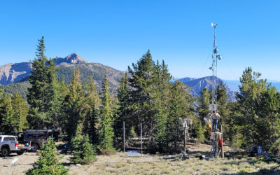
DRI has been studying water evaporation from Lake Powell with the aim of solving this problem by providing more accurate estimates of reservoir evaporation for all major reservoirs throughout the western U.S. Currently, our work leverages field datasets collected via buoys and floating weather stations with advanced hydrometeorological modeling to generate historical and current estimates of evaporation for improved water management.
Although existing research has provided essential data, obtaining water temperature imagery across a reservoir at the necessary resolution has been a critical missing data piece. Now, DRI is part of the National Science Foundation Southwest Sustainability Innovation Engine (SWSIE), which aims to elevate the Southwest as a regional hub of economic development catalyzed by innovations in water security, carbon capture, and renewable energy. DRI, through SWSIE, is working with remote sensing startup Hydrosat to fill this critical data gap.
On August 16, 2024, Hydrosat successfully launched a satellite equipped with high-resolution thermal imaging technology. Hydrosat’s proprietary data fusion model integrates this data with other satellite imagery sources to deliver precise surface temperature measurements at an impressive 20-meter resolution. DRI will use the Hydrosat data of Lake Powell, and existing research, to test our models against it. Hydrosat will launch more satellites, building a constellation to eventually provide daily temperature reading coverage across the Colorado River reservoirs.
This is a groundbreaking development that is expected to revolutionize our ability to measure evaporation, thanks to the significant improvement it will bring about.
Investment from the Governor’s Office of Economic Development’s Knowledge Fund was instrumental in DRI and our partners successfully competing for the SWSIE Innovation Engine funding.