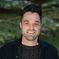
Tyler Doane, Ph.D., started in May 2024 as Assistant Research Professor in the Division of Hydrologic Sciences. He works remotely from Cleveland, Ohio, where his wife teaches bioethics at Case Western Reserve University’s medical school. Doane is a geomorphologist who received his Ph.D. at Vanderbilt University before completing a postdoctoral position at Indiana University, Bloomington.
In the following interview, Doane talks about his interest in applying math to describe scientific phenomena, his interest in embracing noise and chaos to understand Earth systems, and his favorite method for coming up with new research questions.
DRI: Tell us about your background and what brought you to DRI.
Doane: Well, my bachelor’s degree is a classic geology degree, and then when I went to grad school, I transitioned to a more quantitative approach to geomorphology. Before I got to grad school, I didn’t know that you could apply calculus and actual mathematical principles to describe how things worked. That was a real revelation for me, and that’s become my primary toolkit: taking a quantitative approach to explain natural processes and phenomena.
I ended up at DRI partly because I worked with Amanda Keene-Zebert in 2015/2016, so DRI has been on my radar for a while. I was thrilled when a position opened up.
DRI: How did you originally become interested in geology and geomorphology?
Doane: I just liked being outside. The field trips were awesome, and I really liked my professors. Before grad school, I never really realized that you could use math to describe things in a very effective way. I wasn’t good at math, but I thought it was really interesting, and I finally learned that it was not only possible, but useful. My Ph.D. advisor, David Furbish at Vanderbilt, is one of the more quantitative folks in our field. So, I ended up working with him, and he was very patient with me learning math and learning how to apply it, and I’m grateful for that, because it’s changed how I approach the world and the problems that I tackle.
DRI: What are some of the big research questions that you’re interested in?
Doane: As a geomorphologist, I study how sediment moves about on the Earth’s surface. I think that our field is really starting to recognize and handle the fact that sediment transport processes are just really noisy and chaotic. I’m trying to find ways to embrace that noise and explain that noise as a natural consequence of the process, as opposed to something that we should try to smooth over. So, I think that if we can explain the noise of these noisy systems, then we really understand the system.
For example, what are the thresholds of rainfall intensity that drive debris flows? There’s a threshold for how quickly water can go into the ground, and if rainfall precipitation intensity exceeds that, then you have water running over the surface. That’s one sort of threshold, but the infiltration capacity of soils is really, really variable. It’s really noisy, right? So, I think trying to understand things like that and embrace the natural noise of these systems will move us forward on these sort of basic research questions—and ultimately to a greater understanding of threats and hazards like debris flows.
Especially in the context of the changing climate, where extreme events—or events that are well beyond the average—have huge impact, I think that understanding the noise ultimately helps us understand those that affect our lives.
DRI: How do you embrace noise, or chaos, from a mathematical perspective?
Doane: By using probability theory. I think that we’re too often just trying to explain the average behavior. And instead of just trying to explain the average behavior or the mean, we can try to explain the variance or the variability around that. So, to have that as an explicit goal, as opposed to just mentioning that there is variability, we should try to actually explain it.
DRI: What are some projects that you’re working on now?
Doane: Right now, I’m working on the Integrated Terrain Analysis Project (ITAP) and the Urban Flood Demonstration Project.
I also have a Maki funded project that is focused on trying to see if we can use satellite observations to detect surface textural change in post-fire settings. The reasoning is that in a post-fire setting, after it burns, the surface should be relatively smooth because you’ve removed the canopy. And then if it rains hard enough, and you have water flowing over the surface, you’ll get rills carved into the surface, and that is a change to the texture. Some of these satellites that we have are capable of detecting textural change. So, in principle, we should be able to detect that. And if we can do that, then these satellites can tell us where and when water was flowing over the surface, as opposed to going into the ground, which is a critical thing to understand for where and when we have hazards like debris flows and landslides and what drives them.
I also have an ongoing project with NSF funding where we are looking at the topographic signature of trees toppling in forests. When a tree falls in the forest, it creates a pit and a mound, and that persists on the ground for decades to centuries, while all the other geomorphic processes slowly work at it to erode that feature back to a flat surface. And now with high-resolution LiDAR data for the entire country, you can see these pit-mound couplets in the data. So, we’re mapping all of these using Object Detection, focusing on eight states in the northeast right now, which is around 20 to 30 million of these points. And then we’ll maybe expand to the entire country, but right now, it’s sort of a data management problem. Once we have these points mapped, we’ll map the spatial density of them as a function of the hill slope aspect that they’re on, the slope that they’re on, the type of rock that they’re on, and soil depth to try to relate the tree throw frequency to these larger variables.
I think we see a lot of utility in this in the future. For example, every time you knock a tree over, you remove carbon from the above ground carbon mass. Once we have this tool, I think we can start asking a lot more questions about the consequences of tree falls, like “How do trees falling over affect carbon respiration rates and soils as introduced heterogeneity in that process?”
DRI: What research are you most proud of?
Doane: We recently published a paper that explains the topographic roughness of a whole variety of surfaces. It’s largely a theoretical paper, but I think that there’s a lot of potential in the idea that we present in that paper, which is that the topographic roughness of a surface—or the bumpiness of it—is a balance between processes that produce that roughness. For example, the balance between a tree falling over and all the other processes that work to degrade that topographic feature.
And because we now have LiDAR, we can resolve these rough features for many different processes. And by resolving those individual features, we’re able to more precisely zero in on certain processes, whereas before we were sort of lumping them all together in one sort of coefficient, or rate constant, that just describes how fast the sediment is transported, in general. But now that we have this high-resolution data and this theory that relates topographic roughness to specific processes, we can start to pull out certain processes and be a little bit more precise in the questions that we ask. So, we’ve just published this paper that presents the theory. And now there’s a lot of work to be done to actually realize it, and I’m sort of excited about that.
DRI: What do you want your DRI colleagues to know about you?
Doane: One of the joys of studying surface processes is that the surface is truly everywhere on Earth. So presumably, I should be able to ask a question about something everywhere, and I get a lot of motivation just from walking around. I like to be curious about the sort of otherwise maybe mundane things, and I guess I would encourage folks to come to me with unusual questions or thoughts.
For example, this topographic roughness idea was one that I had, many years ago, just walking around in the woods and seeing trees fallen on the ground with pits and mounds. I think the fun projects are the ones you come up with by just walking around and noticing things about the world.
DRI: What do you like to do outside of work?
Doane: I mountain bike. I picked up windsurfing a few years ago because I’m a true child of the 90s. We’ve got a dog named Lefty who we love to take out, and there’s a nice dog beach in Cleveland. I also ski, and I’m looking forward to maybe buying a pass around Reno to use when I come to campus for visits.
DRI: If you could recommend one book to your colleagues, what would it be?
Doane: I read a book several years ago that absolutely captivated me called Shadow Country, by Peter Matthiessen. It’s a historical fiction novel about this outlaw who moved down to the Everglades around 1900 or so. And it was just a wild account of what life was like in the Everglades back then, and how truly wild it was.
DRI: Is there anything else that you want to share?
Doane: Just that I live in Cleveland, but I love coming out to Reno and Vegas, and I will hopefully make myself known, because I do want to take advantage of the time with folks on campus. I know I miss out on a lot being remote, but I appreciate the opportunity, and just want to take full advantage of my time with colleagues when I can.


