The summer 2024 data collection effort provides community members, legislators, and scientists with detailed maps of the region’s urban heat island.
Reno, Nev. (January 13, 2025) – The Reno-Sparks Heat mapping project team is thrilled to announce the successful completion of our community’s temperature mapping campaign and the release of the campaign’s data and modeled temperature maps! This effort, covering nearly 200 square miles of our Truckee Meadows communities, was led by the Nevada State Climate Office at the University of Nevada, Reno (UNR) with support from climate scientists at the Desert Research Institute (DRI). The mapping effort was conducted by more than 100 volunteers from the local community who came together from over a dozen local and Tribal governmental organizations and community groups.
“The primary goal for this project is understanding the variability in space and time of dangerously high temperatures,” says project leader Tom Albright, Deputy State Climatologist and Associate Professor of geography at the University of Nevada, Reno. “It’s really important we understand and mitigate extreme heat because in addition to urban heat islands, Nevada is one of the fastest warming states under climate change,” he added. The ‘urban heat island’ is the term used to describe the tendency of some urbanized areas to be hotter due to greater amounts of concrete and fewer trees and other vegetation. Heat is our state’s and our nation’s most deadly weather-related hazard, with at least 491 deaths attributed to heat in Nevada in 2024. 2024 was the hottest year on record, following the previous record set in 2023. The last ten years are likely the hottest in the last 125,000 years, scientists say.
A summary report and interactive map can be found here:
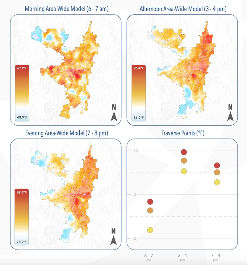
The campaign took place on August 10th, a clear and hot day for our region. The measurements and maps produced from the campaign reveal a great deal of variability across the nearly 200 square miles of our study area and between the early morning, mid-afternoon, and early evening time periods of the study.
In the mid-afternoon 3-4PM window, the hottest time of day, parts of our community were more than 20°F warmer than others. While much of this range was linked to differences in elevation, vegetation and manmade surfaces also play a major role. During the early afternoon heat, the hottest places tended to be low elevation valley floor locations with extensive paved roads and parking lots, and fewer mature trees. In contrast, the coolest areas (such as in neighborhoods along the Mt Rose Highway) tended to have higher elevations and more tree canopy.

The mapping effort also showed how some areas hold onto heat more than others. The industrialized core areas of Reno-Sparks adjacent to I-80 and I-580 remained among the warmest in the community into the evening and even into the early morning hours. In contrast, valley bottom areas farther away from this core cooled down substantially, with some being cooler in the early morning hours than nearby neighborhoods perched on the Sierra slope. Scientists anticipate that these three snapshots of warm-hot temperature patterns are representative of conditions observed on other similarly hot summer days.
These results indicate that people living, working, or learning in different areas of our community may have vastly different exposure to high temperatures. While some areas may have safe temperatures for outdoor activity, other areas may place people at risk for heat-related illness. It may be easy to understand how the hottest afternoon temperatures can be dangerous, but the importance of evening, nighttime, and early morning temperatures should not be overlooked. Comfortable sleeping temperatures are critical to allow people to physiologically recover from daytime heat exposure. At all times of day, there is a great deal of variability in temperatures across our region.
Knowing which areas are subjected to higher temperatures may help our community more precisely target mitigation efforts. Effective efforts include the use of heat-reflective surfaces and water-smart tree planting, employing heat-informed architectural designs, and the use of health advisories to keep community members informed during periods of extreme heat.
“The information collected through this effort will be indispensable for our urban heat modeling research,” says John Mejia, Associate Research Professor of climatology at DRI. “By creating a digital twin of the Reno-Sparks region, we can simulate various heat mitigation strategies to evaluate their cooling effects and identify the most effective solutions for the city. This approach also enables us to analyze the uneven distribution of heat impacts across the area, highlighting how hotter zones face greater challenges such as increased air conditioning costs, infrastructure wear, and heightened water demand.”
The release of these results is just the beginning. The project team is planning a Heat Summit for May 2025 to bring scientists, city agencies, and community members together to discuss the results. More information will be released in the coming months. The data will also be analyzed in scientific studies, used for prioritization and decision making, and act as a baseline as the community works to reduce our exposure to dangerously high temperatures. As temperatures continue to rise in our state and in our world, it will be important to minimize additional heating from local factors that we have more ability to control. And knowing that hot weather is always going to be a part of our climate, being aware of the dangers and being prepared to respond is essential for keeping us all comfortable and protecting the most vulnerable members of our community.
“These heat data are incredibly helpful for Washoe County as we work to find solutions for the region’s increasing heat,” says Brian Beffort, Washoe County Sustainability Manager. “As we think about strategies to address heat and other impacts from our changing climate – such as tree planting and building weatherization – having accurate data at the neighborhood levels very much helps us direct these interventions to places where they will have maximum benefit.”

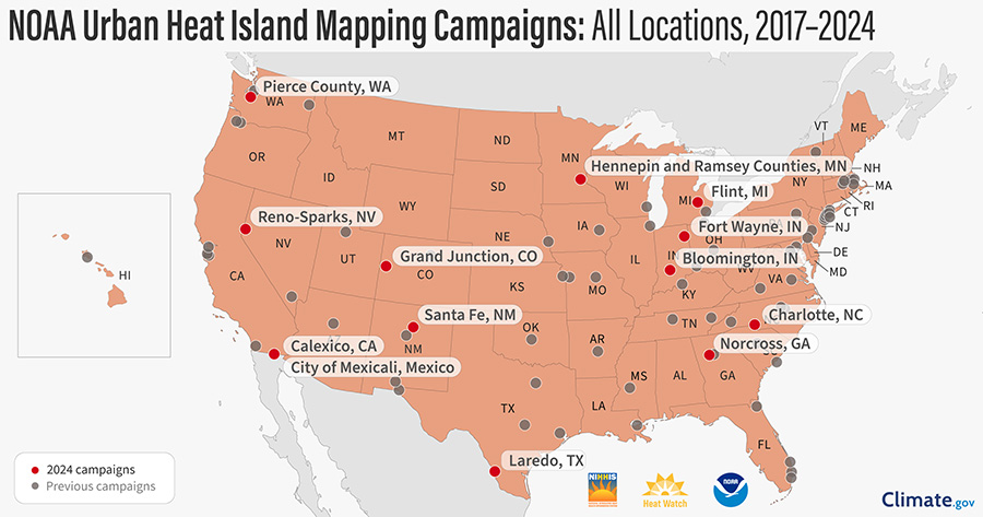
This project is part of the National Oceanic and Atmospheric Administration’s (NOAA) Heat Island Mapping Campaign and was completed with support from NOAA and their partners at CAPA Strategies. To access all the data collected from heat mapping campaigns across the country and the world, visit HEAT.gov.
The Reno-Sparks Heat Mapping Project was made possible through the participation and support from a broad community coalition, including scientists from the Nevada State Climate Office at the University of Nevada, Reno, The Desert Research Institute (DRI), The City of Reno, The City of Sparks, Washoe County, the Reno-Sparks Indian Colony, RTC-Washoe, the Reno-Sparks Chapter of Citizens’ Climate Lobby, Faith in Action Nevada, Make the Road Nevada, Northern Nevada Public Health, and the Truckee Meadows Regional Planning Agency.
###
About the University of Nevada, Reno
The University of Nevada, Reno is a public research university that is committed to the promise of a future powered by knowledge. Nevada’s land-grant university founded in 1874, the University serves 21,000 students. The University is a comprehensive, doctoral university, classified as an R1 institution with very high research activity by the Carnegie Classification of Institutions of Higher Education. Additionally, it has attained the prestigious “Carnegie Engaged” classification, reflecting its student and institutional impact on civic engagement and service, fostered by extensive community and statewide collaborations. More than $800 million in advanced labs, residence halls and facilities has been invested on campus since 2009. It is home to the University of Nevada, Reno School of Medicine and Wolf Pack Athletics, maintains a statewide outreach mission and presence through programs such as the University of Nevada, Reno Extension, Nevada Bureau of Mines and Geology, Small Business Development Center, Nevada Seismological Laboratory, and is part of the Nevada System of Higher Education. Through a commitment to world-improving research, student success and outreach benefiting the communities and businesses of Nevada, the University has impact across the state and around the world. For more information, visit www.unr.edu.
About DRI
We are Nevada’s non-profit research institute, founded in 1959 to empower experts to focus on science that matters. We work with communities across the state –and the world– to address their most pressing scientific questions. We’re proud that our scientists continuously produce solutions that better human and environmental health.
Scientists at DRI are encouraged to follow their research interests across the traditional boundaries of scientific fields, collaborating across DRI and with scientists worldwide. All faculty support their own research through grants, bringing in nearly $5 to the Nevada economy for every $1 of state funds received. With more than 600 scientists, engineers, students, and staff across our Reno and Las Vegas campuses, we conducted more than $52 million in sponsored research focused on improving peoples’ lives in 2024 alone.
At DRI, science isn’t merely academic – it’s the key to future-proofing our communities and building a better world. For more information, please visit www.dri.edu.
Media Contacts:
Elyse DeFranco, DRI
Elyse.defranco@dri.edu
Michelle Werdann
College of Science
University of Nevada, Reno
mwerdann@unr.edu


