Climate change will dramatically impact streamflow and its contributions to the Colorado River by increasing forest water use and reducing groundwater levels, new study finds
Reno, Nev. (May 23, 2024) – The Colorado River makes life possible in many Western cities and supports agriculture that sustains people throughout the country. Most of the river’s water begins as snowmelt from the mountainous watersheds of Colorado, Utah, and Wyoming, and a warming climate will drastically reduce these streamflows, new research finds.
Researchers from Desert Research Institute (DRI), USGS, and Lawrence Berkeley National Laboratory teamed up for the new study, published May 23 in Nature Water. By applying warming to historical conditions for the East River in Colorado and using computer simulations to observe the impact on streamflow and groundwater levels, the scientists found that groundwater storage would fall to the lowest known levels after the first extremely dry year and fail to recover even after multiple wet periods. When groundwater levels fall, streamflows are drawn into the water table instead of contributing to Colorado River flows.
“We found that groundwater matters a lot,” says Rosemary Carroll, Ph.D., DRI research professor of hydrology and lead author of the study. “Even with historically observed wet periods in the model, the groundwater can’t come back from a single dry water year under end-of-century warming.”
The Colorado River has been in a drought state for decades, creating tensions around water rights throughout the Southwest. Scientists have been perplexed by falling river levels even in relatively wet years – in 2021, the Upper Colorado River Basin reached 80% normal snowpack but delivered only 30% of average streamflow to the river. The study authors wanted to examine how warming in mountain basins may be contributing to this phenomenon. Increased temperatures alter the balance between snowfall and water availability in a number of ways, including more snow evaporation (known as sublimation), more precipitation falling as rain instead of snow, and more frequent melting throughout the winter.
Past research has largely overlooked the role of groundwater and how it may buffer, or intensify, streamflow loss from climate change.
“I’m very interested in the relationship of groundwater contributions to streamflow – that has been a running theme in my research for a long time,” Carroll says. “A lot of studies indicate that in the short term, groundwater release to streamflow will help buffer drought impacts, but before this study, we didn’t have any knowledge on what that would mean over the long haul.”

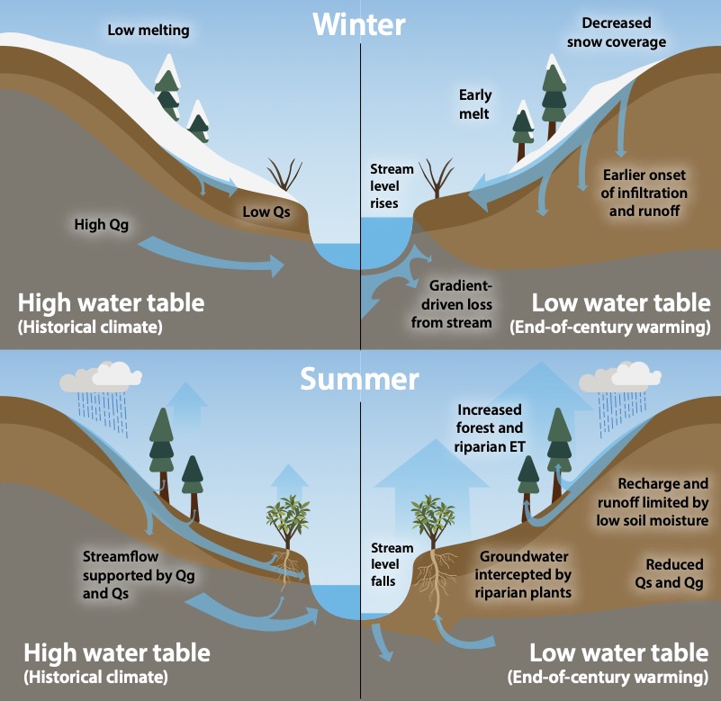
From Figure 2 of Caroll et al.
The study authors used the East River as the focus for the research because it is representative of the headwaters of the Colorado River, as well as the significant weather and water monitoring infrastructure available. Ground observations and airborne mapping measure snowpack depth and density, streamflow, plant cover, and groundwater levels, among many other measurements throughout the watershed.
Historical data from 1987 to 2022 was used to create the computer model. The research team then applied 4 degrees Celsius of warming to this time period in two ways: for one simulation, warming was applied constantly across time, while in subsequent simulations, warming was applied to each season independently. The approach allowed the scientists to examine the differing impacts of warming between seasons. Four degrees Celsius is representative of the projected climate at the end of the century based on observed warming of approximately 0.4 degrees Celsius per decade in the watershed. The simulation doesn’t account for likely changes in vegetation over the same timeframe.
The study showed that consistently warmer temperatures resulted in sharp declines in groundwater levels that were unable to recover to historical average levels during wet periods. Isolating the warming seasonally demonstrated the strong impact of warmer summers on water table declines, as the atmosphere increases evaporation rates, plants increase their water uptake, and soils dry out. The largest declines in water table elevations occur in the subalpine forests where conifer forests are most dense.
“As the groundwater level drops, you lose more streamflow to the water table,” Carroll says. “When precipitation is low, the East River stops flowing for a portion of the summer. Of course, this would have dramatic effects on ecological health and agricultural irrigation.”
By including declining water table levels in the analysis, the study found that streamflow reductions nearly double when compared to simulations that examined the impacts of climate change in the region without accounting for groundwater declines. This is because of the multiple impacts occurring simultaneously: less water flows to streams from the aquifers, while more stream water drains into the soil.

From Figure 8 of Carroll et al.
The research demonstrates the need to jointly manage forest and groundwater in the Upper Colorado River Basin, as well as account for the exchange of surface and groundwater in mountains basins, to minimize streamflow declines under climate change, Carroll says.
“I think of groundwater as your savings account,” she adds. “Snowpack is like your checking account; it changes from year to year. Groundwater is a longer-term investment — it can smooth out the really wet and dry years. But if you start consistently reducing that groundwater year after year, then you can no longer modulate those extremes.”
###
More information: The full study, Declining Groundwater Storage Expected to Amplify Mountain Streamflow Reductions in a Warmer World, is available from Nature Water at https://www.nature.com/articles/s44221-024-00239-0
Funding for the study came from the U.S. Department of Energy Office of Science and Office of Biological and Environmental Research.
Study authors include: Rosemary Carroll (DRI), Richard Niswonger (USGS), Craig Ulrich (Lawrence Berkeley National Laboratory), Charuleka Varadharajan (Lawrence Berkeley National Laboratory), Erica Siirila-Woodburn (Lawrence Berkeley National Laboratory), and Kenneth Williams (Rocky Mountain Biological Laboratory)
About DRI
We are Nevada’s non-profit research institute, founded in 1959 to empower experts to focus on science that matters. We work with communities across the state — and the world — to address their most pressing scientific questions. We’re proud that our scientists continuously produce solutions that better human and environmental health.
Scientists at DRI are encouraged to follow their research interests across the traditional boundaries of scientific fields, collaborating across DRI and with scientists worldwide. All faculty support their own research through grants, bringing in nearly $5 to the Nevada economy for every $1 of state funds received. With more than 600 scientists, engineers, students, and staff across our Reno and Las Vegas campuses, we conducted more than $47 million in sponsored research focused on improving peoples’ lives in 2023 alone.
At DRI, science isn’t merely academic — it’s the key to future-proofing our communities and building a better world. For more information, please visit www.dri.edu.


