A new study maps, for the first time, the permanent loss of aquifer storage capacity occurring globally
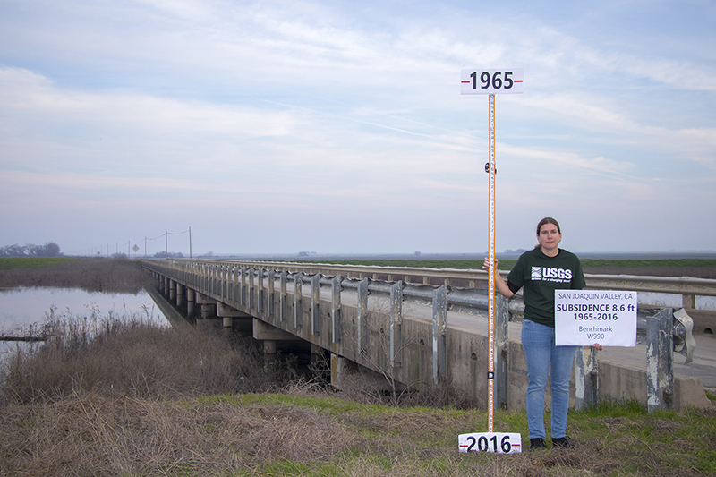
Reno, Nev. (Nov. 2, 2023) – Global water resources are stretched by climate change and human population growth, and farms and cities are increasingly turning to groundwater to fill their needs. Unfortunately, the pumping of groundwater can cause the ground surface above to sink, as the aquifers below are drained and the architecture of the ground collapses. For the first time, a new study maps this loss of groundwater storage capacity around the world.
In the study, published October in the journal Nature Communications, researchers from DRI, Colorado State University, and the Missouri University of Science and Technology examined how groundwater extraction is driving land subsidence and aquifer collapse.
“Our study puts land subsidence happening from excessive groundwater pumping to a global context,” said Fahim Hasan, a Ph.D. candidate at Colorado State University and the study’s lead author.
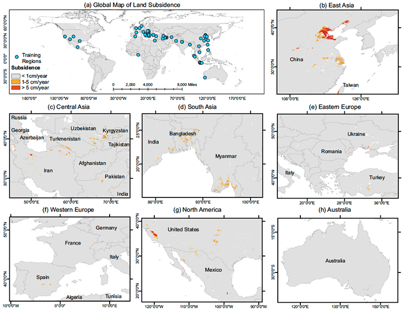
By combining publicly available data with the predictive capabilities of computer modeling, they found global aquifer storage capacity is disappearing at a rate of approximately 17 km3 per year (about the size of 7,000 Great Pyramids of Giza). This loss of groundwater storage is permanent, forever reducing the amount of water that can be captured and stored. Approximately 75% of this subsidence is occurring over cropland and urban regions, underscoring the importance of improving groundwater management globally.
“With this study, we wanted to understand land subsidence dynamics globally, and at a sufficiently high resolution to help local management authorities,” says Sayantan Majumdar, Ph.D., assistant research professor of hydrologic sciences and remote sensing at DRI who co-authored the study.
To identify and quantify how much land is subsiding due to groundwater pumping in regions where no data is available, the team utilized advanced machine learning techniques. They first compiled all the publicly available information they could find from federal and state agencies and scientific studies. Then, they used this data to build a computer model that can use risk factors for land subsidence, like land use and climate data, to produce statistical predictions for ground subsidence in other regions. They tested the accuracy of the model’s predictive capacity by assessing how well it predicted subsidence in regions where subsidence has been verified. In this way, they could expand the study to include rural and little-studied regions around the world.
“Most regions of the world do not have monitoring programs for groundwater pumping,” Majumdar says. “This kind of data is crucial for helping understand the issue on a global scale.”
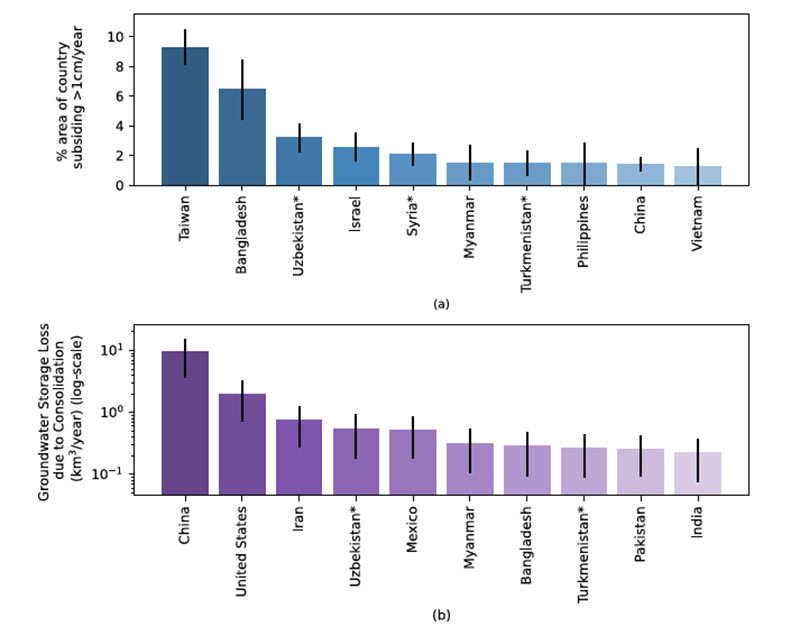
The study found that the United States, China, and Iran account for most of the global groundwater storage loss, with some regions experiencing more than 5 cm/year of land subsidence. California ,and Arizona show significant land subsidence due to the arid region’s reliance on groundwater to irrigate crops. In places like Mexico City, subsidence is more strongly tied to urban groundwater use.
The research also predicts high land subsidence rates in both irrigated and urban regions of Afghanistan, Uzbekistan, Azerbaijan, and Syria, where no previous data has documented the impacts of groundwater withdrawal. Although the study predicts that most of Europe is experiencing low rates of land subsidence of less than 1 cm/year, the authors note that even this amount can cause damage to infrastructure and create issues for coastal regions that are also threatened by sea level rise. Additional consequences of land subsidence include arsenic contamination and saltwater intrusion, both of which can impact the quality of the remaining groundwater.
The problem is not limited to arid regions, the study authors note, with subsidence mapped throughout humid climates like Bangladesh, India, and Vietnam. This underscores a high reliance on groundwater even in regions where rainfall is plentiful.
The scientists hope that water managers can use their data to understand the scale, and extent, of groundwater storage loss occurring in their region.


More information: The full study, Global land subsidence mapping reveals widespread loss of aquifer storage capacity, is available from Nature Communications at https://doi.org/10.1038/s41467-023-41933-z
Study authors include: Md Fahim Hasan, Ryan Smith, and Rahel Pommerenke (Colorado State University), Sayantan Majumdar (DRI), and Sanaz Vajedian (Missouri University of Science and Technology)
More on the study from Colorado State University: https://www.engr.colostate.edu/ce/smith-and-hasan-develop-model-for-monitoring-subsidence-and-groundwater-storage-loss/
###
About DRI
The Desert Research Institute (DRI) is a recognized world leader in basic and applied environmental research. Committed to scientific excellence and integrity, DRI faculty, students who work alongside them, and staff have developed scientific knowledge and innovative technologies in research projects around the globe. Since 1959, DRI’s research has advanced scientific knowledge on topics ranging from humans’ impact on the environment to the environment’s impact on humans. DRI’s impactful science and inspiring solutions support Nevada’s diverse economy, provide science-based educational opportunities, and inform policymakers, business leaders, and community members. With campuses in Las Vegas and Reno, DRI serves as the non-profit research arm of the Nevada System of Higher Education. For more information, please visit www.dri.edu.
Media Contact:
Elyse DeFranco
Science Writer, DRI
E: elyse.defranco@dri.edu


