As populations in the southwestern United States continue to grow, the demand on water resources also increases. One region experiencing this stress on its groundwater resources is Pahrump Valley in southern Nye County, Nevada. Pahrump Valley is one of the fastest growing counties in Nevada, which has led to groundwater-related issues such as land subsidence. “Land subsidence has been reported in Pahrump Valley since the 1960s,” says Dr. Hai Pham the principal investigator (PI) of this project, which also includes co-PIs Karl Pohlmann, Susan Rybarski, and Kevin Heintz and research assistant Larry Piatt. “It has caused damage to building foundations and slabs, fissuring, shearing of well casings, and extensive damage to roadbeds.”
In their 2017 Water Resources Plan Update, the Nye County Water District determined that land subsidence is one of the key issues related to population growth in Nye County. However, the causes of land subsidence still haven’t been clearly identified. “Previous studies failed to precisely map spatiotemporal evolutions of subsidence, or adequately clarify the causes of subsidence,” Pham says. “These studies were limited by data quantity and quality. The goal of this project is to identify and prioritize predominant factors that cause subsidence and make predictions using machine learning algorithms and big data.”
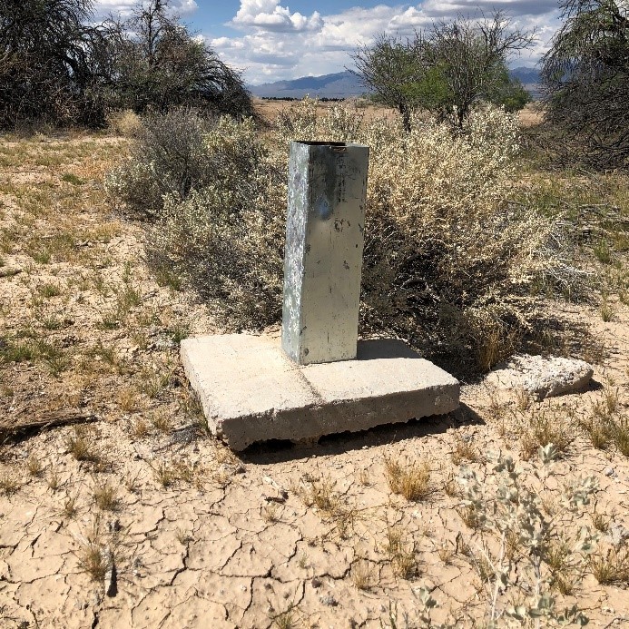
A concrete well pad exposed by land subsidence around the well casing (right) observed during a field survey in May 2019 (photo by Karl Pohlmann).
Land subsidence is a complicated process that is driven by multivariate intercorrelated factors, such as groundwater decline, soil and sediment types, and tectonic and geologic settings. For example, excessive groundwater pumping results in soil compaction, which has been identified as a primary cause of land subsidence in Pahrump Valley. However, the magnitude of soil compaction depends on aquifer materials, and therefore understanding the geologic structure of Pahrump Valley is vital to evaluating future subsidence. The advantage of using machine learning to assess potential areas of land subsidence is that it can help illuminate complicated data relationships that may not be as obvious using traditional data analysis techniques.
In this project, the researchers will use machine learning algorithms and high-resolution data sets to identify the predominant factors causing land subsidence in Pahrump Valley. “In this study, we will derive spatiotemporal subsidence maps using recent high-quality satellite images and the Interferometric Synthetic Aperture Radar [InSAR] technique,” Pham says. “InSAR is a powerful technique that allows us to measure and map vertical changes on the earth’s surface as small as a few millimeters.”
The researchers will then build three-dimensional (3-D) computer models of the subsurface geological structures in Pahrump Valley at a very fine (one-foot) vertical resolution using data from 13,000 boreholes. “Compaction of aquifer materials can accompany excessive groundwater pumping and it is by far the single largest cause of subsidence, but the magnitude of soil compaction differs by soil type,” Pham explains. “Therefore, it is important that we account for these well log data to construct high resolution 3-D models of geologic structures.” The researchers will also develop groundwater drawdown maps by processing data from records of 130 groundwater observation wells that range from the 1940s to the present. “Incorporating these high-resolution datasets will help us identify and prioritize the causes of subsidence and make better predictions,” Pham adds.
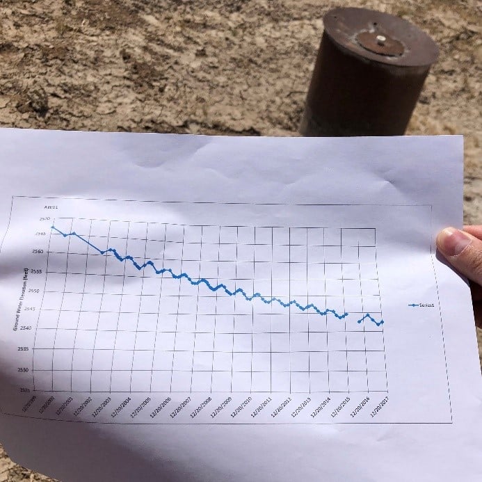
The groundwater level has declined approximately 25 feet from December 1999 to December 2017 (photo taken in May 2019 by Karl Pohlmann).
Because of the limitations of existing field data, the researchers will generate high-resolution datasets to train and validate the machine learning algorithms. Advanced machine learning algorithms will then be run on supercomputers to analyze the data. By analyzing this data, the researchers hope to identify the factors that cause subsidence and ultimately predict possible subsidence in the future. “Once we have identified these factors, we can roughly predict areas that are prone to subsidence,” Pham explains. “This information can also be used to predict subsidence in other arid and semiarid regions.”
This story was originally written for the Nevada Water Resources Research Institute (NWRRI) October 2019 Newsletter. Success and the dedication to quality research have established DRI’s Division of Hydrologic Sciences (DHS) as the Nevada Water Resources Research Institute (NWRRI) under the Water Resources Research Act of 1984 (as amended). The work conducted through the NWRRI program is supported by the U.S. Geological Survey under Grant/Cooperative Agreement No. G16AP00069.